GPS
This article refers to the address: http://
The application of GPS systems is very extensive. Including vehicle navigation, geophysical resource exploration, municipal planning control, marine rescue, aircraft navigation, missile guidance and so on. But what is most sensible to us is the navigation service that is most closely related to our lives.
The GPS system generally consists of three parts: the ground control system, the space satellite, and the ground receiving device. There is only one ground receiving device among the devices used for navigation. The ground unit receives signals from space satellites and calculates its own position. With location information and complex spatial data processing technology, the navigation device can easily send you to your destination and query the information you are interested in.
In recent years, GPS navigation devices have become more and more popular. In Japan, car navigation devices using GPS signals have been available for nearly 20 years. Many people have witnessed the process of car navigation equipment from expensive luxury goods to mass popularization. There are more than a dozen manufacturers in Japan producing car navigation equipment. In addition to the original navigation equipment installed at the same time as the new car sales, there are more than 50 kinds of car navigation devices retailed in Japan in the year, with an annual sales of about 1 million units.
According to statistics, the penetration rate of car navigation devices in Japan is now around 36%. Because the usage rate of commercial vehicles is relatively low, the penetration rate should be higher if it is only for family cars. In addition, a large number of personal navigation devices (PNDs, Personal Navigation Device) are being used.
Auto navigation and GPS
Car navigation devices are one of the most widely used GPS navigation services. However, car navigation devices are only equipped with automatic navigation methods such as vehicle speed pulses and compass sensors. Devices using such automatic navigation methods rely on the device itself to derive the position of the vehicle. Therefore, it is only possible to roughly tell the driver the current position and the route to the destination. After driving for a period of time, you must adjust the location, direction of travel and driving angle. It is extremely inconvenient to use and it is not accurate. It is just a general location service. Therefore, when car navigation equipment was first seen at the auto show in Japan, the focus of many manufacturers was on the accurate positioning of the vehicle.
The GPS method is now very popular, and the method derives the position of the vehicle by GPS. However, only by GPS, there will always be some degree of error in design. At the time, in Japan, because of the error of the signal transmitted by the US satellite, the vehicle sign (a triangular arrow) on the navigation device often ran to the sea, making people laugh and laugh.
Therefore, in order to compensate for the shortcomings of both parties, Japanese manufacturers combine GPS and automatic navigation method devices to calculate the position of the vehicle, which solves the problem of accurate positioning of the vehicle self-discipline. Now even if the vehicle enters a cave, such as a place where satellite signals cannot be received, the position of the car on the navigation device will appear on the road of the map very accurately. With the advancement of technology, navigation devices that simply use GPS signals have also entered the market in large numbers. GPS has gradually become the mainstream technology of various navigation devices.
GPS navigation and LBS
The exact spatial position coordinates obtained by GPS alone are meaningless. Navigation equipment must be combined with location-based information services (LBS) to facilitate people's lives and generate huge economic benefits. With the GPS module embedded in many mobile devices, LBS has gradually become the next value-added service that mobile operators are developing. In Japan's car GPS navigation equipment, LBS is very user-friendly. After the navigation device detects the location of the vehicle itself, it queries the information (POI) of interest to the user and prompts the user.
The number of POIs in maps in Japan's navigation devices is very rich, such as gas stations, restaurants, banks, post offices, and even toilets. This function is very effective when driving to a relatively unfamiliar area or in the middle of the night, and it can solve problems in a short time. In addition, when you are traveling, you can also learn about the places of interest, memorial halls, museums, service offices, stadiums, leisure places, etc. in a certain area through search options (such as station, leisure, address, etc.). Searching, saving, etc. are also very simple. Just use your finger to point in the direction you want to go, and you can lock the desired target. The navigation device also stores 10 million phone numbers and 30 million home phone numbers in the Japanese Yellow Pages. In other words, as long as the phone number is entered, the path from the vehicle location to the destination can be easily retrieved. Some places that have been visited can be activated as soon as they are searched in the saved directory. When you go home, just press the home button and the navigation device will retrieve a convenient home route based on the earliest conditions.
The map display of Japanese navigation devices also reflects the location service. When the ratio is below 50 meters, the one-way street and its direction will also be displayed on the map. When the ratio is 10 meters, you can even set which side of the road your car is on. The display of the map can be flat or stereo, and the stereo can be displayed as a bird's eye view and a driving view. The stereo image will display the landmark in the corresponding location.
GPS navigation and ITS
The Intelligent Transportation System (ITS) organically combines roads, drivers and vehicles to strengthen the connection between the three. Provide changing traffic conditions such as traffic information and traffic jam information to people in need in real time to enhance driving safety, reduce travel time, and guide driving routes.
The Japanese government and enterprises form a joint organization of ITS. The organization is equipped with a variety of monitors and smart devices on the road to collect dynamic information about the road in real time. Such as: speed, flow, road conditions, etc. This information is then aggregated and analyzed and ultimately transmitted over the wireless network to interested navigation devices. With this information, the navigation device can provide multiple driving routes according to different priority conditions when retrieving the destination. Drivers can decide which one of them is easy to get on the road according to their own preferences. Of course, if the driver is not at ease, he can also check the content of each search route before going on the road. At this point, the navigation device will display the name and distance of the road that each section passes, including the cost of using the toll road.
When you decide on a route, this route will appear as a bold line on the map of the navigation device, straight or turn at a glance. The navigation device will prompt you to drive the line all the way. At each intersection, the screen displays the same logo and content as the street sign on the actual road, including the name of each intersection. The driver can just confirm his location and the direction he should go by listening to voice navigation. At many intersections, you will be told which lane to take, turn left or right. The screen will also show several lanes at the intersection, and whether there is a detailed screen of the dedicated lane that turns left and turns right. Even if you miss the opportunity to turn at an intersection for various reasons, the navigation device will automatically retrieve a route based on the location of the vehicle to guide you. In addition to displaying maps, navigation and driving tracks, it also displays compass, time, traffic jam information, remaining distance and scheduled time from the destination, as well as administrative divisions and specific place names where the vehicle is now. All of this will tell the driver in real time with a voice.
GPS navigation and entertainment
With the popularity of navigation devices and the competition of many manufacturers, many manufacturers integrate entertainment functions and navigation devices. Japanese car navigation devices have been able to watch TV, listen to music, watch videos and even surf the Internet, and have moved the entertainment environment that the family can enjoy to the car.
Navigation device data
The GPS data belongs to the map data, and the GIS data belongs to the geographic data. Map data is a subset of geographic data. Map data, like geographic data, consists essentially of spatial data, non-spatial data, and time factors. Spatial data is a graphical representation of a feature object with spatial features. Spatial features refer to geometric features such as the location, shape and size of spatial features, as well as spatial relationships with adjacent features. In the GPS system, each object space is composed of a set of points with coordinates of latitude and longitude and a high degree.
The spatial relationship of each object is also calculated from the coordinate points. In daily life, people rely on the relative positional relationship of various objects to determine the spatial position. Non-spatial data is primarily an attribute of a spatial target. It refers to other features of spatial phenomena other than temporal and spatial features. Such as traffic flow, weather, air pollution, road width, etc. The time characteristic is a description and performance of the spatial target and its properties over time, such as the congestion situation will change with time.
According to the characteristics of GPS data. People abstract abstract spatial objects and use mathematics to express them into four categories: digital line data, image data, digital elevation models, and attribute data. Among them, the digital line data and the attribute data are the most interesting data in the current GPS navigation system. The digit line data is an entity that directly abstracts a spatial feature into points, lines, and faces, and describes its position and shape in coordinates. Digital line data is the core of GPS and the main object of map data processing. However, GPS has become so rich, so widely used, it is very convenient for us to have its attribute data. The attribute data of the space target is not limited, and any necessary related attributes can be set according to different targets.
At present, the most used in the processing model of map data is the topological vector data model (space objects can be described as vector data. Topological vector data models represent the topological relationships of inclusion, intersection, separation, and neighboring between these vector data. A mathematical model), while the attribute data model usually uses a relational model. The way in which the topological vector's graphical data and relational attribute data are connected is also a question that needs careful scrutiny. The more common approach at present is to extend the RDBMS to increase spatial data management.
Whether it is navigation, location services or intelligent transportation, a lot of query, update and delete of map data is needed, so how to index spatial data is very important. Common spatial indexing methods generally divide the geospatial space step by step, and divide the query space into several regions. Thereby forming various spatial index structures. The divided area contains spatial elements and has a unique identifier. Our common grid series index and R-tree series index are based on space partitioning, except that the former is based on the rule partitioning method. The latter is based on object partitioning.
Space (navigation) database
Spatial database can seamlessly connect spatial data, image data and attribute data, which is the mainstream of data processing in geographic information systems. The navigation database can be regarded as a subset of the spatial database (some people think it is an intersection), and refers to a map database with uniform technical standards established for processing various spatial data and attribute data of GPS. It is capable of storing spatial data and attribute data, and indexing the data so that other applications can quickly access the data, and is responsible for processing the relationship between spatial data and attribute data. The content can be described as geographic framework information with spatial data (road network, etc.) as a skeleton, on which attribute data (social economic information and traffic information) are superimposed.
Several enterprise-level spatial databases mature in the market store spatial data in RDBMS, but RDBMS does not provide spatial data types (such as points, lines, polygons, etc.) at the beginning, nor does it provide data types for these spatial data. Operation (such as: judging the relationship between inclusion, neighboring, intersection, etc., and the calculation of difference, distance, shortest path, etc.). Later, people developed support for the storage and operation of spatial data based on RDBMS. The common treatments are as follows:
A variety of spatial data types can be defined in the database, each of which stores specific information in binary form, and stores description information (called spatial metadata) for the binary data. Each spatial target (object) is a specific value that conforms to the specifications of this binary field. By storing the spatial data in the form of a binary field, both the spatial data and the attribute data can be simultaneously present in the same table, which greatly facilitates the operation of the spatial data and the attribute data.
In addition to spatial data, with the development of navigation devices, the processing of image data and the processing of multimedia data must also be solved. This involves another topic - the multimedia database. However, the products of some large enterprise database providers can basically meet the processing requirements of spatial databases and multimedia databases. The spatial database provides a variety of interfaces that are easy to understand and invoke, shielding complex and abstract methods of storing and computing various spatial data, making it easy for end users to spend space without having to spend a lot of effort to understand these complex processes. Processing of data.
For example, the Empress database stores, inserts, and modifies spatial data in the same way as ordinary relational data. An Insert/update statement can be used; the relationship between query space targets can also be implemented with simple SQL statements. A simple select statement can query complex topological relationships such as adjacent, intersecting, and inclusion between several spatial objects. The spatial database provides a simple and convenient way for developers to complete the storage and operation of spatial data. How spatial data is organized can also affect specific applications. When applied in navigation, the organization of the data should aim at the efficiency of path optimization and target finding. In this way, when data is stored, it should be considered how the specific spatial data and attribute data are divided into different sets and associated, thereby making the specific application more efficient. Especially in the embedded field, due to resource constraints and efficiency requirements, targeted optimization must be carried out. Empress space (navigation) database in the embedded field
Now, in enterprise applications, everyone uses a spatial database to process spatial data and attribute data, and the relationship between the two, it is very convenient to retrieve and update this information. In the embedded field, it is difficult to have a better spatial database product. This is because the memory space of the embedded domain and the storage space of the disk are limited, and the processing power of the CPU is also limited. Some existing providers of embedded databases can only provide the most basic relational data processing engine or structured data processing engine, and basically have no data processing engine for spatial data processing. However, the Empress embedded database has accumulated over 30 years, providing not only a relational and structured data engine, but also a database engine for spatial data processing. There are many examples in many military projects in North America. Of course, as mentioned earlier, optimization for the navigation field is necessary, and Empress is also working on this for the world's leading manufacturers.
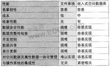
In the domestic embedded field, many manufacturers still insist on the way of documents. The reason is very simple. The main reason is that they have not seen the successful application of mature embedded databases in this field in China, and it is difficult to convince themselves. So, here's a quick comparison of the embedded domain spatial database and file system.
The spatial data management engine in the Empress embedded world not only provides standard and extended SQL statements, but also provides a high-speed and flexible C language interface. because. In the embedded world, stability, speed and performance are often the first priority in order to reduce system overhead. To increase the flexibility of data processing, you must have a high-speed and flexible interface.
In addition, the embedded world is also sensitive to the engine size of the database. The size of the spatial data management engine in the Empress embedded world varies depending on the features selected by the customer. The engine can be embedded in the final application, transparent to the end user, and requires no maintenance.
The following is a brief introduction to some of the changes that the world's largest automaker has brought to the data processing core components of in-vehicle navigation devices using the Empress embedded spatial database.
First, complex compound search and fuzzy search can be performed. For example: “To find a three-star hotel with the name “Jin†in the area within 10 km from Tiananmen Square in Beijing and within 3 km from Beijing Railway Stationâ€. This kind of retrieval is difficult to achieve by using a file method, and it is very expensive even if it is barely realized. In the embedded spatial database, it is easy to implement and the efficiency is very high.
Secondly, the spatial data and its attribute data in the database can be updated in real time, and the security of these updates should be guaranteed to prevent repeated updates, invalid updates and even damage to the consistency of the original data. The Empress spatial database uses transactions, various granular locks, etc. to achieve these goals.
Finally, different users can set their own personalized data and personalization features. When using navigation, it will be based on the identity data of the individual. And produce different search results. Moreover, the user's private data can be encrypted at the engine level to ensure absolute security.
Gas Stove,Gas Burner,Gas Cooker
Stainless Steel Gas Hob,Tempered Glass Gas Hob Co., Ltd. , http://www.nsgasstove.com